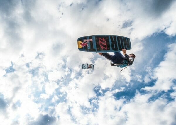
Trekking and paragliding through the woods and Lake Garda views

Davide Fambri
Mountain bike, ski touring and paragliding

Angela Trawoeger
Creator, photographer and content manager

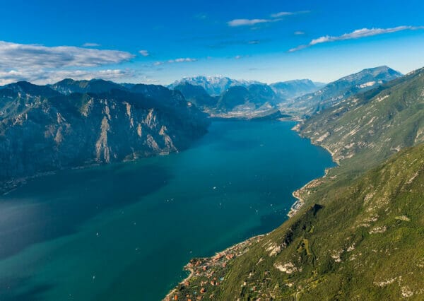
A tough climb leads you from the landing of the paragliding of Malcesine to the take-off location of Tratto Spino on Monte Baldo. Waiting for you there are 1700 meters of height difference on 9 kilometers of uphill and about thirty minutes of flight, without termic wind.
The trail is full of shortcuts and it’s the shortest way to reach the top of Monte Baldo starting from the landing. Shortest does mean the steepest too. Some uphills are really steep and this route is suggested for fit people or for those who like to struggle.
This is also the trail of the new hike ad fly race organized by the Paragliding Club Malcesine at the end of the summer. Take advantage to test the route, to train and to get in shape for the race. 😉
Details of the trekking route
Map and GPS-Track
Infos
-
Technical characteristics
-
Starting point
Malcesine
-
Endpoint
Tratto Spino
-
Route
Malcesine – San Michele – Signor – Prai – Monte Baldo
-
Starting height
64m
-
Highest point
1760m
-
Altitude – ascent/descent
1736m/47m
-
Distance
9km
-
Duration
3 hrs
-
Starting point
-
Difficulty
-
Difficulty
difficult
-
Technical difficulty (1 to 5)
3
-
Physical training (1 to 5)
4
- CAI (Italian Alpine Club) difficulty scale
-
Difficulty
-
Scenic appeal
- Experience (1 to 5)
-
Landscape (1 to 5)
4
-
Type of route
- Panoramic route
- Summit tour
- One way route
- Suggested route
-
Best time of year
-
From april to december
without snow
-
From april to december
Partner
Trekking tour description
From the landing at Malcesine you start on the cycle lane heading south and after a few hundred meters enter the first steep road on the left. Go ahead and climb the stairs to reach a small street surrounded by olive trees, turn right and go straight south for some minutes and reach Via Navene Vecchia.
Here there is a short flat stretch. After the Ristorante Pizzeria Cervo, before starting the downhill, take the uphill road on the left that becomes a muletrack. At the first crossroad, near the shrine, head right and keep going up. Once the muletrack is over go straight over the tarmac up to Via Panoramica. Continue to the right and take the first uphill on your left that ends not far from the middle station of the cable car in San Michele. Cross the road and take the shortcut through the wood which leads you right under the cable car station.
Now keep on going up leaving the station behind you.
Take the road on the left and immediately turn right into the wood along a trail that comes out on the concrete road of Prai. Go up on the right and enter the first trail to the left to return into the wood that shortly takes you back on the concrete road of Prai. Continue straight for a few meters then take the next shortcut in the wood to the right of the curve that bends to the left. You will be back on the road of Prai close to the shrine of Signor. At Signor keep left following the road to Prai for about 1,5 kilometers, then take the trail on the right with indications for Funivia/Monte Baldo which is located just below the Prai at about 1300m of altitude.
Now you climb on a trail with loose stone bottom that leads to a clearing with some benches. Go straight leaving the benches behind you and enter the wood on a route with loose ground and underwood, quite challenging, that reaches the final stretch of the uphill under the poles of the cable car. Out of the wood the trail is on hard terrain and ends on Monte Baldo.
Here turn left, pass in front of the top station of the cable car and continue straight for about another kilometer until you reach the take-off at Tratto Spino.
Trekking route variant
You can start from the middle station of the cable car in San Michele to make the route 3,5 kilometers shorter. The height difference starting from San Michele is about 1200 meters.
In San Michele there is a small free parking lot above the station while the other to the north is for a fee.
Partner
Take-off
45 N 46.70 – 010° E 51.80
The take-off is wide, grassy and without stones: it’s perfect to hang out before take off. During the take-off pay attention to the areas bounded for pastures.
With the wind from the west, you immediately fly over the lake with the landing clearly visible. With the east wind you exit on the east side passing through Bocca Navene, which is located further north of the landing.
When the Ora, the south wind, is stronger than your progress you may not reach the landing on time.
Before you leave, especially if you don’t know the conditions of the landing, contact Michele from the Paragliding Club Malcesine by radio and he can give you information about the wind.
Flight duration
Thirty minutes without termic winds.
Landing
45° N 46.930 – 010° E 49.070
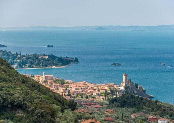
The landing is clearly visible during the flight and it lies along the lake shores, two kilometers north of Malcesine.
The landing is managed by the Paragliding Club Malcesine; the use is free for single flights but not for the commercial ones. In the event of a landing in the water, during summer season, a recovery service with a boat is almost always available , for a fee and managed by the club.
Here you can find the complete Club rules with contacts.
The winds
If on take-off you find wind from east or west, on landing, on a day with stable weather, you find wind from north (Pelèr) in the morning or from south (Ora) in the afternoon. In the evening, however, you may find Montès, a wind that descends from Monte Baldo and tends to take you out towards the lake. During the change of the two winds, usually from mid-morning until midday, you may find moments of stall.
Requirements to fly in Malcesine
To fly in Malcesine you must have:
- the licence
- insurance
- a life jacket
If you don’t have a life jacket you can ask for it directly at the club at the landing after 10:00 in the morning or go to Claudio, the club president, at Hotel Ideal at via Gardesana 228. He will also give you some advice on the flight and on the weather.
Our suggestions
- Remember to consider the weather conditions both in the mountain and by the lake because you will find two different winds for direction and intensity.
- Take lots of water with you because during the uphill there aren’t any shelters or refreshment points.
- Weather can change rapidly at Lake Garda. If in doubt ask the club or the locals at the landing or at the take-off.
- In case of need or difficulty better to land in the water instead of risking some dangerous manoeuvers.
- In the event of landing in the water remove your harness immediately.
The tour during the winter
It is to avoid if it snows and during the colder months. Remember that during winter the recovery service of the Club isn’t available.
Shelters, huts or bivouacs along the trail
None.
On the top of Monte Baldo
- Baita dei Forti 10 metres from the cable car Station
- SkyWalk Lounge Bar Monte Baldo At the cable car station on Monte Baldo
- Bar Ristorante La Capannina At Colma di Malcesine
Partner
How to reach the starting point of the trail
The landing lies two kilometers north of Malcesine.
You can reach it by foot, by car or with the Tourist Bus, operative during summer, that stops at the landing. The only drawback is that if you take it from Malcesine, it does not pass in front of the landing and you have to get to Navene (6km further north) and go back to Malcesine before going down in front of the landing.
Close to the landing there is also a small pay-parking lot. During high season, it is almost always full. You can also park at Retelino, shortening the walk from the center by one kilometer.
Parking lot
In Malcesine, by distance:
- Park place Piazza Statuto
- Park place Campogrande
- Park place Paina
- Park place Retelino
- Park place close to the landing
Public transport
- From Torbole or Riva del Garda take a bus travelling south in the direction of Peschiera/Verona.
- From Peschiera or Verona take a bus travelling north in the direction of Riva del Garda.